The Sad Saga of Amtrak Harold Bypass

Amtrak Unlimited Discussion Forum

Help Support Amtrak Unlimited Discussion Forum:

This site may earn a commission from merchant affiliate links, including eBay, Amazon, and others.

jis

Permanent Way Inspector
Staff member
Administator
Moderator
AU Supporting Member
Gathering Team Member
Joined
Aug 24, 2003
Messages
39,361
Location
Space Coast, Florida, Area code 3-2-1
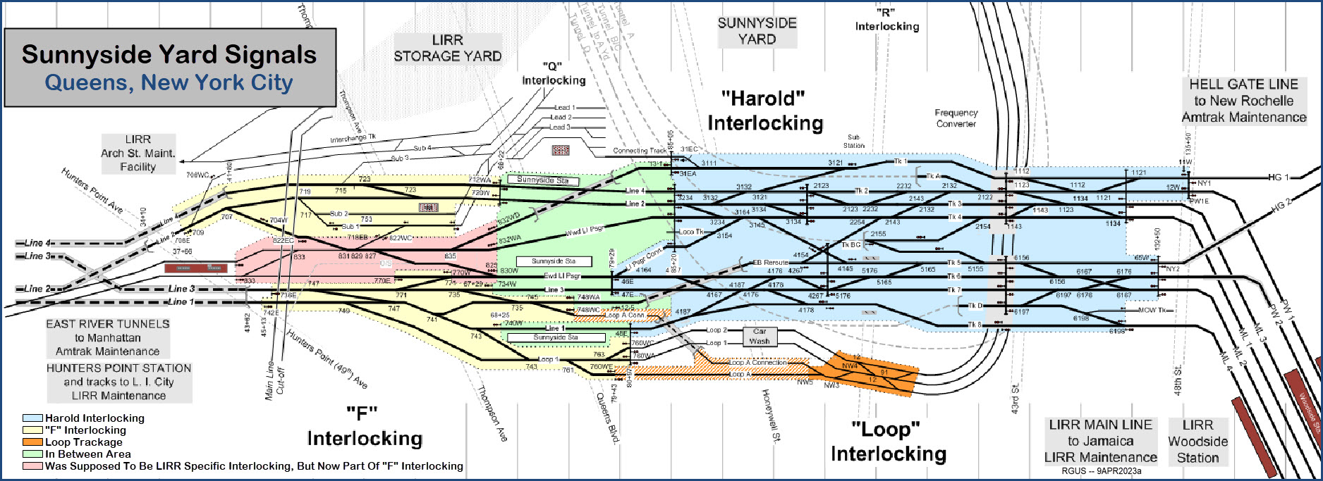
After mentioning the Harold Bypass earlier in another thread, I got curious about whatever happened to this project started in 2013. What I discovered left me in such a state of disbelief that I had to go back and read the material from the NEC Commission Project Status Reports a couple of times to make sure I was reading about the project I thought I was reading about

After a whole afternoon's worth of research and reading many dozens of pages of project status documentation from the NEC Commission I discovered that the bypass track project the construction on which started in 2013, finally stalled in a few years because LIRR and Amtrak could not agree on a schedule. It took them some four years to finally come to an agreement. Meanwhile the project cost grew year by year, and of course there is absolutely no one who is responsible individually for any of it. Constructions started again in 2020 at a slow pace, and now it is expected to be fully completed by 2025.

So it will take all of 12 years to complete a few miles of track and two duck unders, of which seven of those twelve years consisted of doing mostly nothing other than to watch the cost grow. Typical MTA. It is ostensibly an add-on to the the ESA project.

Its is funded through HSIPR. ARRA and local + Amtrak funds. The total cost now stands at $1.4 Billion with a capital B, and includes some additional changes to the Sunnyside Loop tracks and a bunch of building demolition in Sunnyside Yard and relocation of the Amtrak car wash. Allegedly it is now fully funded and work continues. This year they will get around to ordering parts for the westbound track, and they hope to get the eastbound bypass commissioned next year, and get the westbound done by 2025.
 
Last edited:
Whenever the MTA (or any agency of New York government) gets into a construction project, you know there will be design flaws, construction delays, and cost overruns. Designing in the 21st century a "bypass" that does not allow for evacuation of a passenger train is crazy.
No one said that an emergency evacuation is not possible. You are reading way more into what was stated. It is transfer to another train on the next track that is not possible in part of it. No single track railroad in the world has the facility to transfer people to a train on a nonexistent parallel track. But they all allow people to get off the train and walk away from it.
 
Last edited:
Way bank in Amtrak's David Gunn era, for the disruption that East Side Access construction caused Amtrak in Sunnyside Yard, he insisted LIRR in return build for Amtrak these bypasses. They could also come in handy for Metro North's East Bronx service, not contemplated back then, though we don't know which Penn Station tracks and tunnel tubes they will normally use. That is about 5 or 6 years away.
 
Way bank in Amtrak's David Gunn era, for the disruption that East Side Access construction caused Amtrak in Sunnyside Yard, he insisted LIRR in return build for Amtrak these bypasses. They could also come in handy for Metro North's East Bronx service, not contemplated back then, though we don't know which Penn Station tracks and tunnel tubes they will normally use. That is about 5 or 6 years away.
This was funded out of ARRA in 2009. Before that there was no project. Gunn may have talked about it, but Boardman is the one in whose time it got funded.
Oh, I don't know. If that bridge project had required the UP to work and coordinate with another railroad company in a densely populated urban area, it might be just as slow and expensive as a public sector project.
I agree. Having worked all my life in large private sector corporation I am not as enamored of the private sector as some here appear to be from time to time.
 
MODERATOR'S NOTE: The public sector vs. private sector discussion has been moved to its own thread in the Freight, International and Other Rail Forum:

https://www.amtraktrains.com/thread...vs-public-sector-construction-projects.81200/
This thread is for discussion specific to the Harold Interlocking project in the context of Amtrak Bypass and by extension the ESA related reconfiguration since the Bypass is a part of that project.
 
Last edited:
Since many, including me, have been confused about what exactly is bypassed how by the Harold Bypass, here is a diagram to get a better understanding (The diagram is a product of railguides.us and it is included here by URL reference. All rights belong to them):

SunnysideSignals202JM.jpg


Everything in the diagram is now in service except for the two Harold Bypass Tunnels for Amtrak's use, and the Sunnyside Station (which is not currently funded). For the Harold Bypass the ROW is more or less done but is yet to receive tracks and catenary. You can see its location on the diagram. The westbound is in the Green area shown with a dashed line to depict tunnel. The eastbound is in the left bottom corner of the Blue area, again shown with a dashed line depicting tunnel.
Anyway, have fun figuring the complexities of Harold out when you find the time. This diagram also shows the location of all signals.
 
Perhaps someone could tell me why my idea is wrong, but I am never sure why they did this route, as I don't know if the eastbound bypass makes sense.

I thought the EB bypass should have gone south of the facility from Track 1 (the EB Amtrak tunnel) rising to a viaduct east of the 39th street bridge. (Yes, there would likely have to be property taken from the Major Chevrolet Service) It rises up over the LIRR tracks and merges with the existing NB Amtrak tracks between 54th and 32nd Avenue.

This, it seems, would have allowed the existing EB track to become a WB track -- and there's pretty much a straight shot from that track to its tunnel.

I can see under the current plan a number of conflicts with trains coming out of the center GCM tunnel. Would this route allow for fewer delays and some more congestion relief?
 
A major problem with that idea - there's no room for that kind of structure. Assuming you're not talking about making changes to the original East River tunnels, there's only about 1/4 mile available (between the Montauk Cutoff structure and the Thompson Ave bridge) to raise the track level about 40-50' (in order to clear Thompson Ave with sufficient clearance to not cause problems. That's at least a 4%+ grade - since you also need to include vertical curves at the beginning and end of it. You need to go even higher to clear the subway viaduct at Queens Blvd (only another 1/4 mile away), so now you've raised the tracks about 75 feet, and you're not going to be able to even start coming back down until you get past 39th St. Making those kind of elevation changes at a reasonable grade (less that 1%) requires about 3 miles to go up and then down again - even a 1.5% grade (which is considered stiff) would need at least a mile to go up and another mile to come back down again. Doing that in 1/4 mile? Not a chance.
 
A major problem with that idea - there's no room for that kind of structure. Assuming you're not talking about making changes to the original East River tunnels, there's only about 1/4 mile available (between the Montauk Cutoff structure and the Thompson Ave bridge) to raise the track level about 40-50' (in order to clear Thompson Ave with sufficient clearance to not cause problems. That's at least a 4%+ grade - since you also need to include vertical curves at the beginning and end of it. You need to go even higher to clear the subway viaduct at Queens Blvd (only another 1/4 mile away), so now you've raised the tracks about 75 feet, and you're not going to be able to even start coming back down until you get past 39th St. Making those kind of elevation changes at a reasonable grade (less that 1%) requires about 3 miles to go up and then down again - even a 1.5% grade (which is considered stiff) would need at least a mile to go up and another mile to come back down again. Doing that in 1/4 mile? Not a chance.
I agree with the issues raised concerning the impracticality of an EB flyover on my old route for the existing overpass clearance reasons given. On the other hand, with 20-20 hindsight I've daydreamed for over 40 years about the one missing piece in Alexander Cassatt's and Samuel Rea's original, incredible NY Terminal vision. At the time, PRR-NH trains in DC-NY-BOS service amounted to about 5-6 trains/day plus a handful of mail/express runs out of Sunnyside, so who can fault them for seeing no issue in getting these few runs over the LIRR ROW at grade? Crossing Lines 2 and 3 over one other was deemed sufficient to handle the overall PRR/NH/LIRR movements then projected. How could they have foreseen the torrential confluence of the present LIRR and Amtrak NEC floodwaters, with GCT out of the through train business entirely? If they had, where would we be starting from today had Line 3 been aligned to cross over both Lines 2 and 1 back when they were first laid out before 1910?
 
Back
Top