The Padma River Bridge in Bangladesh

Amtrak Unlimited Discussion Forum

Help Support Amtrak Unlimited Discussion Forum:

jis

Chief Dispatcher
Staff member
Administator
Moderator
AU Supporting Member
Gathering Team Member
Joined
Aug 24, 2003
Messages
35,786
Location
Space Coast, Florida, Area code 3-2-1
Munshiganj-Padma-Bridge-01.jpg


https://bdnews24.com/economy/2018/03/11/third-span-of-padma-bridge-installed

The Padma Bridge is being built spanning the Padma River. This channel carries most of the water flowing down both the Ganges and Bramhaputra draining all of North India and the Tibet plateau, essentially all the water that carries down from the Himalayas east of Simla. Allegedly, it has a greater flow, specially during Monsoon, than any single channel of even the Amazon in its estuary. Padma at this point (a rather narrow portion of it) is a bit over 6km (about 4 miles) wide and more than 100m (~325 feet) deep in places, with unusually rapid flow so close to the sea, and rapidly moving sedimentary formations.


The main bridge consists of 41 spans 150m each (almost 500') carrying one (160kph/100mph passenger 120kph/75mph freight) rail track in a run through truss with planned capacity of 40 train per day initially going up to 4tph eventually after electrification, and a deck above the truss carrying a four lane highway. Each of the 42 pylons sit on piling driven into the river bed as much as 400m ((1,300') below the bed. The bridge is designed to withstand earthquakes of upto magnitude eight.


Upon completion of this bridge and the related railroad connection to Jessore, travel time from Kolkata to Dhaka will go down to below four hours (from the current 8+ hours).

If things stay on course it will come in at the third most expensive bridge in the world. The project is currently funded about 2/3rds by China through a loan and 1/3rd by Bangladesh.

Incidentally it is likely that the 4th through 6th span at the south end of the bridge will go up within the next couple of months. The they wills tart installing spans on the north end while the redesigned pylons to account for clay at the bottom of the river are constructed mid river.

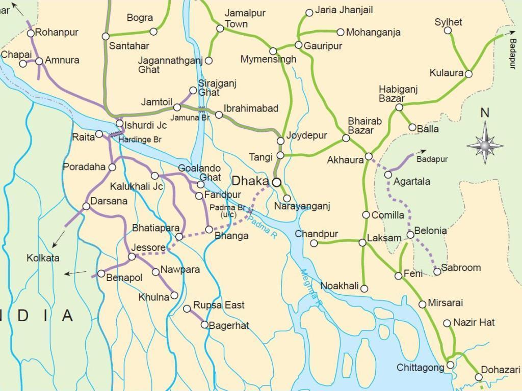
A betting man would guess that the bridge structure may be completed and ready for use by late 2019. The initial rail connection to India from this bridge will be via Bhanga - Faridpur - Kushtya (near where it joins the current route of the Dhaka - Kolkata service via the Gede border.

For reference, here is a map:

railway-network-map-bangladesh.jpg
 
Last edited by a moderator:

jis

Chief Dispatcher
Staff member
Administator
Moderator
AU Supporting Member
Gathering Team Member
Joined
Aug 24, 2003
Messages
35,786
Location
Space Coast, Florida, Area code 3-2-1
Well, the New York East Side Access Project is a technically remarkable, and remarkably overpriced project. The San Francisco Bay Bridge replacement is a great one too, though not as hard to build as this one.

The Gateway Project if and when it happens will cost way way more than this bridge but won;t be anything as remarkable as it, unfortunately. Hudson is a very pretty but really tiny river.
default_smile.png
 
Joined
Mar 10, 2016
Messages
1,744
NPR's Marketplace had a program (ok, well, ok, a piece about) about tunneling costs in Nu Yawk. Way higher than anywhere else.

So the bridge is basically between Dhaka and Faridpur, more or less, on the map?
 

jis

Chief Dispatcher
Staff member
Administator
Moderator
AU Supporting Member
Gathering Team Member
Joined
Aug 24, 2003
Messages
35,786
Location
Space Coast, Florida, Area code 3-2-1
The core bridge route is from Dhaka to where the green line ends south of Faridpur, that is Bhanga. The actual 6km bridge is across the stream that passes close to Faridpur but south of it, by Bhanga. The other stream closer to Dhaka (Burhiganga) used to be once upon a time, a major channel of the Ganga. It is not any more. The route will of course cross that too, but not on something considered a major bridge. Just around 1km or so, and pretty shallow flood stream mostly.

Major movement of streams and channels is a major headache in bridge building. They have to train the river to stay in its channel and not decamp somewhere else. To give you an example of huge channel movements, Bramhaputra which comes in from the north and joins the Padma a little north of Faridpur, Back in the mid 18th century it used to flow mostly through a channel flowing into the Meghna River which flows on the east side (right of Dhaka), and there was very little flow into the main Ganga channel Burhiganga nearer Dhaka, from Bramhaputra. The current Padma Channel was a lesser channel. All these flows got shuffled after a major earthquake in the late 18th century raised the Mymansingh Plateau slightly, causing the Bramhaputra to flow further west and join the Ganga where it does today, and convert Padma into this Godzilla channel that it is today.

Consequently, there is about a total of a hundred miles of river bank protection and training work involved to ensure that the darned river continues to flow under the bridge after it is built, rather than somewhere else.


Sent from my iPhone using Amtrak Forum
 
Last edited by a moderator:
Joined
Mar 10, 2016
Messages
1,744
Funny you should mention the shifting channels. I was trying to locate the bridge on google maps and on bing maps and the channel was totally different in each of them. Google maps showed the piers of the bridge construction. I was just reading about why the Amazon has no bridges - they would need to be 30 miles long for the high water periods to be able to make it across the flooded channels....
 

jis

Chief Dispatcher
Staff member
Administator
Moderator
AU Supporting Member
Gathering Team Member
Joined
Aug 24, 2003
Messages
35,786
Location
Space Coast, Florida, Area code 3-2-1
I found this really nice map showing the new rail route that is being constructed (the dashed line between Dhaka and Jessore) in connection with the Padma River Bridge. It shows clearly how this will considerably shorten the running time on the international Maitree Express between Kolkata and Dhaka, maybe down to as little as five to six hours.

tn_bd-padma-map.jpg
20793_tn_bd-padma-map.jpg


Incidentally they have started constructing the rail deck on the girders that are already in place for the bridge. Completion of the bridge realistically will be late 2020 or early 2021 it seems.
 
Last edited:

jis

Chief Dispatcher
Staff member
Administator
Moderator
AU Supporting Member
Gathering Team Member
Joined
Aug 24, 2003
Messages
35,786
Location
Space Coast, Florida, Area code 3-2-1
After four years of construction the bridge is getting close to completion


The link to Joshore (erstwhile Jessore) will become part of a much shorter route for the international Kolkata - Dhaka service, making it a run of less than five hours, instead of an all day affair.
 
Last edited:

jis

Chief Dispatcher
Staff member
Administator
Moderator
AU Supporting Member
Gathering Team Member
Joined
Aug 24, 2003
Messages
35,786
Location
Space Coast, Florida, Area code 3-2-1
I am surprised only a single track on the bridge. Hope that does not become a very expensive to fix bottleneck.
You build what you can pay for I suppose. Already many in Bangladesh are unhappy with the amount that is financed through China. Any more cost would have sunk the whole project.

Anyway it is designed for 6tph in each direction. Given similar corridors that are being built say between Dhaka and Chittagong that would appear to be more than sufficient until the second planned bridge at Goalondo is built in a few decades.

Funny you should mention the shifting channels. I was trying to locate the bridge on google maps and on bing maps and the channel was totally different in each of them. Google maps showed the piers of the bridge construction. I was just reading about why the Amazon has no bridges - they would need to be 30 miles long for the high water periods to be able to make it across the flooded channels....

Here is an article about the meandering and moving channels of the Padma. The place marked as Char Janajat in the first frame is where the new bridge is located and the river has been trained into a fixed channel with extensive bank stabilization.


A more concise location map of the bridge relative to Char Janajat can be found at:


Here is a nice animation of the river's movement over the last several decades....


The difficulty of building a bridge across that is obvious and explains why the bridge is over 6km long.
 
Last edited:

jis

Chief Dispatcher
Staff member
Administator
Moderator
AU Supporting Member
Gathering Team Member
Joined
Aug 24, 2003
Messages
35,786
Location
Space Coast, Florida, Area code 3-2-1
The 6.15kM long New Padma Bridge in Bangladesh is already open for road traffic on the upper deck. Rapid progress is being made in laying the ballastless rail track on the lower deck. The video does not have any commentary, only music, so language fluency is not a problem.


In a few years when the entire route from Dhaka to Joshore is completed, Joshore and Khulna will be within 3.5 hours running time from Dhaka compared to over 10 hours now. The time for traveling from Kolkata to Dhaka will be reduced to around five hours from the current slightly more than 12 hours.
 
Last edited:
Top