How Steep Is It?

Amtrak Unlimited Discussion Forum

Help Support Amtrak Unlimited Discussion Forum:

This site may earn a commission from merchant affiliate links, including eBay, Amazon, and others.

MrFSS

Engineer
Honored Member
Joined
Mar 13, 2004
Messages
9,712
Location
Central Kentucky
Saw this on another group I read. Can you believe this is a light rail line?

1170533149_a516fdd2b3_b.jpg
 
Sacramento, I presume from the "Bee" news-box. Any idea which station that is, or what the line is going over?
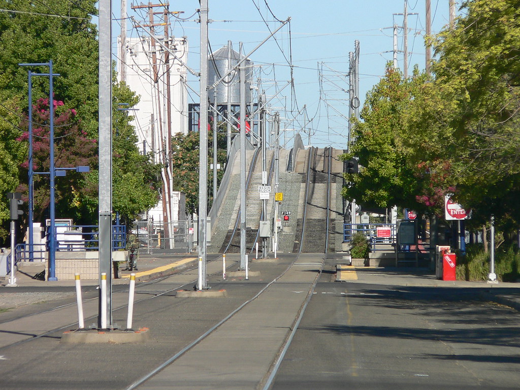
It is Sacramento - but I don't have any other details. I don't think the incline is as drastic as it looks. The long lens shot is what is making it look that way.
 
Supertelephoto.

Grade is likely to be 6% or less. 6% is not a problem on a light rail and is commonly used. For that matter, 6% is not a problem on short grades for any system where most of the axles have motors. A long grade would be more of a problem operationally, particularly downhill where stopping becomes a problem.
 
Telephoto lenses compress distance, and distort perspective, so the grade is probably not as steep as it appears. And at any rate, electrics, at least running light, are much better on grades than steam or diesel. Of course there are exceptions. The Cass Scenic, which runs geared locomotives - mostly Shays - features one grade which is advertised as 9%. Wow.

South of L.A. there is a flyover used by both Amtrak and Metrolink. The trains get a running start out of LAUS. I don't know what the gradient is, but even in the passenger cars - push or pull - you can feel that the locomotive is laboring near the top, and the speed drops.
 
Telephoto lenses do indeed compress perceived distance. What is probably a full block on the street looks to be much less than 100 feet in the picture. So the length of the incline appears very short compared to it's actual length, but the perceived height stays the same. So the gradient appears MUCH steeper than it actually is. If you look closely at the picture, notice how cluttered it looks as you moved further away from the camera. Look how close together the power poles are not just in the street, but the big wooden power poles off to the right as well. Way too close together....
 
Last edited by a moderator:
Aloha

I am driving myself crazy trying ((frying)see) to remember where that is. With OTOL group I think it was on the route to Folsom, or the route to the mall and lunch.
 
Last edited by a moderator:
South of L.A. there is a flyover used by both Amtrak and Metrolink. The trains get a running start out of LAUS. I don't know what the gradient is, but even in the passenger cars - push or pull - you can feel that the locomotive is laboring near the top, and the speed drops.
Have been told by someone that should know that the grade for this track is 3.00%

This is the Redondo Junction Flyover and gets the passenger trains over the UP and BNSF lines to the Alameda Corridor, which takes the container trains to/from the port. In addition to reducing conflicts, it raised the speed limit from 15 mph to 40 mph for passenger trains through this location.
 
Saw this on another group I read. Can you believe this is a light rail line?
1170533149_a516fdd2b3_b.jpg
That looks like the 23rd St Light Rail Station on the Folsom Sunrise Gold Line. From the photo that would be looking westbound towards 16th St and Downtown that is the bridge over the Sacramento Bee facility although I suspect that shot may have been from a zoom lens because the incline is actually not that steep in person. Ironically this is the same line that now terminates at the Amtrak Station.

Mark Del Monte
 
That looks like the 23rd St Light Rail Station on the Folsom Sunrise Gold Line. From the photo that would be looking westbound towards 16th St and Downtown that is the bridge over the Sacramento Bee facility although I suspect that shot may have been from a zoom lens because the incline is actually not that steep in person. Ironically this is the same line that now terminates at the Amtrak Station.
Here's a view of it:

http://maps.live.com/default.aspx?v=2&...8&encType=1
 
Kramerica's link, if you explore it, shows that the grade is really mild. I was using the apparent water tower as a landmark. In the telephoto it seems to be right there, in the foreground. In reality, it's on the far end of the flyover. What's that about pictures don't lie, and seeing is believing? HAHA!!
 
From THIS perspective, you can see that the photo was taken from almost two full blocks in front of the beginning of the grade change. You can count the number of center poles. In the photo above, there are four, and you can see in my link that there are two per block. Other points of connection include the YIELD sign by pole two (from the foreground), and the stop sign that is just before the 2nd intersection.

Very impressive focal length!! This sort of photo has to be taken on a bright day with the apature as small as it will get.
 
Back
Top