L
Lori
Guest
This may be a silly question, but I am traveling from chicago to boston (potentially) on this train. A co-traveller is deathly afraid of heights. Does this train go through any mountains or over bridges?


Is it that flat through the Berkshires where it crosses the Appalachian watershed? The rest I agree is flat, being the so called "Water Level Route".Nope. Pretty flat trip. I can't think of any high bridges offhand either.
It still hugs the river basins.Is it that flat through the Berkshires where it crosses the Appalachian watershed?
The highest point on the route I think is in there somewhere. Pittsfield is around 1100'. The summit which is east of Pittsfield at MP 138.7 (Washington), is a little higher, river basin or not. That is way higher than the rest of the route. I don't think the Berkshire section was ever called the "Water Level Route". That monicker applies to the New York to Chicago route. I am yet to hear a trained geographer call the Berkshires a "River Basin". Whatever....It still hugs the river basins.Is it that flat through the Berkshires where it crosses the Appalachian watershed?

") ), You do climb up a valley where the river is flowing to the east (into the Connecticut basin) and then down a valley where the river is flowing west (to the Hudson basin).
), You do climb up a valley where the river is flowing to the east (into the Connecticut basin) and then down a valley where the river is flowing west (to the Hudson basin).Specially when approaching on the Lackawanna Cutoff and the newer interstates, since they are built near the top of the ridges and not in the valleys.Yeah, it goes up a bit in the Berkshires, but you're running along the river with the mountains above you; it's not going to trigger fear of heights. From Springfield it's up the Westfield River, up Depot Brook, over the pass, down the East Branch Housatonic River, up the Southwest Branch, over the pass, down Fairfield Brook & Cone Brook, cut across Furnace Brook, back up Flat Brook, over the pass at "Tunnel Hill Road" (one 500 ft. tunnel, the only one on the route IIRC), down Stony Kill, and finally the Post Road Branch to Albany.
This isn't totally flat, but if you can tolerate being on the second floor of a building, it's not going to trigger your fear of heights. The heights are all above you, and frankly they aren't that high anyway. It isn't like Scranton.
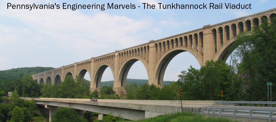
And then there is the spectacular Tunkhannock Viaduct, seemingly as solid as earth itself! Amazing that it was one of the first, then state of the art, concrete structures built to that scale!Some of those high roads in Scranton actually scare the hell out of me. The Pennsylvania Turnpike NE Extension particularly, with its gigantic, aging steel bridge from hilltop to hilltop.
Nearly.. Yet I've managed a speeding ticket on it, my brother has, and the girlfriend, so has my mom.I love the Northeast extension. Nearly no cops, excellent scenery, and coming back from the Poconos at night, I can really open my Benz up.
It's the section from exit 112 to 131 which scares me, specifically. The coin-throw bit after the end of the ticket system.I love the Northeast extension. Nearly no cops, excellent scenery, and coming back from the Poconos at night, I can really open my Benz up.
I know it stinks with all of the construction, but there's always I-81 on the other side of the valley. I always get off at Pittston and never take the upper section unless there is an accident on 81.It's the section from exit 112 to 131 which scares me, specifically. The coin-throw bit after the end of the ticket system.I love the Northeast extension. Nearly no cops, excellent scenery, and coming back from the Poconos at night, I can really open my Benz up.
And you really can't go very fast on that section, it's far too twisty. There's an actual 120 degree turn at the Clark's Summit end, as well as several sharp 90 degree turns.
The rest of the NE extension is fine.
But that bit at the end from Wyoming Valley to Clarks Summit has this bridge:
Wait.... Nicholson Viaduct is Tunkhannock Viaduct. It is the viaduct across the Tunkhannock Creek in the town of Nicholson. Perhaps you mean the Delaware River Viaduct near Slatreford, or the Paulinskill viaduct in Hainesburg on the Cutoff? Or there is another viaduct a little further north of Nicholson, I forget its name off the top of my head. Route 11 passes under the cutoff at that one.The viaducts of the DL&W (there are several others in the same style as the Tunkanhonnack Viaduct, including the Nicholson Viaduct) look much more solid than the NE Extension bridge.
There are almost none and their hiding spots are obvious and limited.Nearly.. Yet I've managed a speeding ticket on it, my brother has, and the girlfriend, so has my mom.I love the Northeast extension. Nearly no cops, excellent scenery, and coming back from the Poconos at night, I can really open my Benz up.
If I had your car, I bet I'd be going faster than I do now. One of the things that really impresses me with it is the low COG. I drive a BOF SUV, and are therefore limited in how fast I can drive.It's the section from exit 112 to 131 which scares me, specifically. The coin-throw bit after the end of the ticket system.I love the Northeast extension. Nearly no cops, excellent scenery, and coming back from the Poconos at night, I can really open my Benz up.
And you really can't go very fast on that section, it's far too twisty. There's an actual 120 degree turn at the Clark's Summit end, as well as several sharp 90 degree turns.
The rest of the NE extension is fine.
But that bit at the end from Wyoming Valley to Clarks Summit has this bridge:
https://maps.google.com/?ll=41.483827,-75.690876&spn=0.005666,0.009184&t=h&z=17
Street view from below:
https://maps.google.com/?ll=41.483293,-75.691139&spn=0.000708,0.001148&t=h&z=20&layer=c&cbll=41.483293,-75.691139&panoid=eUy6cI2JHZwLygJ635bQ4Q&cbp=12,320.61,,0,-26.39
I started taking I-81 for that segment of travel instead.
The viaducts of the DL&W (there are several others in the same style as the Tunkanhonnack Viaduct, including the Nicholson Viaduct) look much more solid than the NE Extension bridge.
I'm thinking of the little one a bit north of Nicholson. The other two you mention are also the same design -- I guess it was a bit of a "standard design" for the Lackawanna.Wait.... Nicholson Viaduct is Tunkhannock Viaduct. It is the viaduct across the Tunkhannock Creek in the town of Nicholson. Perhaps you mean the Delaware River Viaduct near Slatreford, or the Paulinskill viaduct in Hainesburg on the Cutoff? Or there is another viaduct a little further north of Nicholson, I forget its name off the top of my head. Route 11 passes under the cutoff at that one.The viaducts of the DL&W (there are several others in the same style as the Tunkanhonnack Viaduct, including the Nicholson Viaduct) look much more solid than the NE Extension bridge.
Enter your email address to join: