Hi all -- I see the youtube videos with GPS systems and scanners travellers set up in their rooms, but I can't tell what kind to buy? That is, the GPS units I see only have the 12 volt car accessory outlets. The trains have the wall outlet - do people use an inverter, or is there a GPS unit that comes with a regular wall socket? And what kind of scanners do people use on the train that allows them to hear the crew communications?
You are using an out of date browser. It may not display this or other websites correctly.
You should upgrade or use an alternative browser.
You should upgrade or use an alternative browser.
Using a GPS and scanner - what kind?
- Thread starter John King
- Start date


Help Support Amtrak Unlimited Discussion Forum:
This site may earn a commission from merchant affiliate
links, including eBay, Amazon, and others.
- Status
- Not open for further replies.
Devil's Advocate
⠀⠀⠀
I've only used the portable GPS systems that run off rechargeable batteries. Same thing with my scanner as well. Do you have any links to the specific videos you're referring to?
Currently, since railroad transmissions are not trunked or digitalized, any scanner you pick up at Radio Shack will work.Hi all -- I see the youtube videos with GPS systems and scanners travellers set up in their rooms, but I can't tell what kind to buy? That is, the GPS units I see only have the 12 volt car accessory outlets. The trains have the wall outlet - do people use an inverter, or is there a GPS unit that comes with a regular wall socket? And what kind of scanners do people use on the train that allows them to hear the crew communications?
fredevad
Lead Service Attendant
If you get a GPS that connects to the computer, then all you need to do is find a wall outlet power supply that matches the USB connector. Many cell phones come with such power supplies. When I had my TomTom GPS, I used the charger for an old Motorola Razor cell phone. As long as the USB plug matches, you should be fine. Be careful though, some look alike but are NOT the same - don't force it. If you don't have an old cell phone power supply, just take the GPS to your local Radio Shack and they should be able to set you up.Hi all -- I see the youtube videos with GPS systems and scanners travellers set up in their rooms, but I can't tell what kind to buy? That is, the GPS units I see only have the 12 volt car accessory outlets. The trains have the wall outlet - do people use an inverter, or is there a GPS unit that comes with a regular wall socket? And what kind of scanners do people use on the train that allows them to hear the crew communications?
Nowadays, my cell phone IS my GPS. The downside is that if the train goes into an area that doesn't get data coverage, you won't see the maps because it pulls the maps from the internet. The Droid phones come with a USB cable and a wall adapter that the USB cable plugs into.
As someone else wrote, any scanner will work. Just make sure you have and use a headset (I like to use earbuds) when you're in public areas of the train or when your door is open (if you're traveling in a sleeper). In my case, the earbuds that I use for my cell phone (iPhone earbuds) also work with the scanner. What kind of scanner you get should depend on what you want to listen to, if and what trunking systems they're on, and how much time you're willing to spend learning to program it (it can get fairly technical for many of the public safety systems). The good news is that programming for rail frequencies is the easiest.
As far as the youtube videos - can't find a specific link right now. As I watch youtube videos, searched for videos of CL and TE sleeping accomodations, sometimes you see the GPS wires hanging down and the videomaker briefly references the GPS.
I have a Macbook, and the DeLorme is for windows. Does anyone have experience using the DC/AC inverter?
I have a Macbook, and the DeLorme is for windows. Does anyone have experience using the DC/AC inverter?
rtabern
Conductor
I use my Garmin Nuvi that I use in my car... and it works great... except going through tunnels of course. It's the 255 model I think -- the cheapest model that has real-time traffic on it.
And, I have a Radio Shack scanner with a special antannea that I got off a website for like $27 that helps picks up signals further away. I live about 7 miles away from the CP Track Detector at MP 72.7 on the CP/Amtrak line between CHI and MKE and can pick up the readings at my house.
And, I have a Radio Shack scanner with a special antannea that I got off a website for like $27 that helps picks up signals further away. I live about 7 miles away from the CP Track Detector at MP 72.7 on the CP/Amtrak line between CHI and MKE and can pick up the readings at my house.
Tumbleweed
OBS Chief
Will this work with Windows 7?I own a 12v GPS for my car AND a computer powered (USB) GPS for the train. I bought this set and I plug it into my netbook and its GREAT. :giggle:
I've little experience with mac's, but DeLorme claims that Street Atlas will run on a mac under boot camp. I use it on my Windows netbook running Windows 7 with their LT-40 usb gps and it works quite well (outside of tunnels) on the train.
Alternatively, you might try Google maps on a smartphone.
Alternatively, you might try Google maps on a smartphone.
Last edited by a moderator:
OlympianHiawatha
Engineer
Remember to bring a short to medium length extension cord, especially in Viewliner Roomette where the power is on the toilet side of the room. By the time you throw a camera or 2 and other gadgets into the mix, you'll need the extra outlets.
fredevad
Lead Service Attendant
I recommend carrying a 6 ft. extension cord with you. When traveling in a roomette, run it from the outlet to between the window and the table. In a bedroom, run it from the outlet (which is located near the door) to the other side of the bench seat (near the window).As far as the youtube videos - can't find a specific link right now. As I watch youtube videos, searched for videos of CL and TE sleeping accomodations, sometimes you see the GPS wires hanging down and the videomaker briefly references the GPS.
Referencing this video (one of my latest Travelogue entries):
At 2:11, you can see where I have my "GPS" (i.e. Android phone showing Google Maps with the Latitude feature overlay) mounted on the window. Then at 2:49 you can see a white 6 ft. extension cord that runs from the door side of the bench seat to the window side, where the phone's power supply is connected.
Devil's Advocate
⠀⠀⠀
Bootcamp refers to running a secondary operating system at boot time. You'd still need to buy a copy of Windows and install it on your Mac in order to make use of Bootcamp.I've little experience with mac's, but DeLorme claims that Street Atlas will run on a mac under boot camp.
Last edited by a moderator:
Ryan
Court Jester
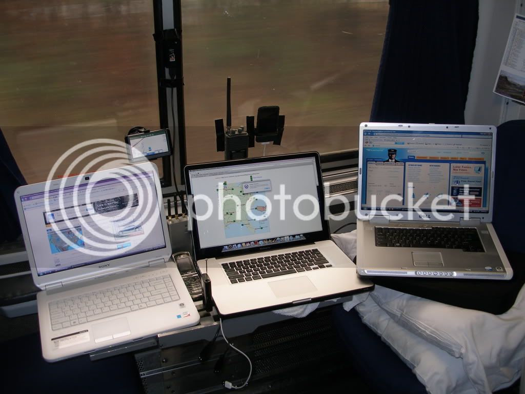
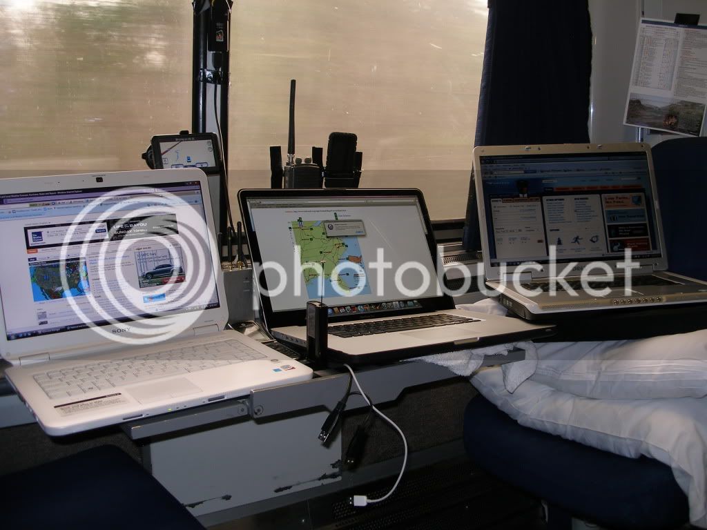
Here's my usual setup:
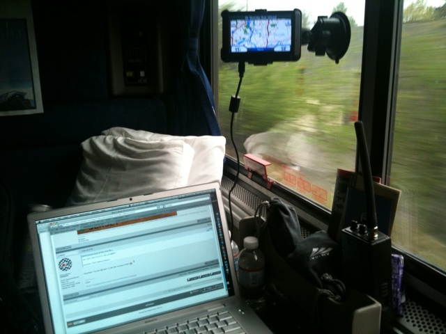
The GPS is plugged into the computer via USB to keep the internal batteries charged, as is my phone (which also provides internet access whenever I have a cell signal). Scanner is just a standard Radio Shack jobber (I forget the model number). 1 plug in the wall and all the gadgets stay happy (except the scanner, but that's pretty easy on the batteries).
I've not found any decent mapping solutions that run directly under OS X. If you want to go with something like DeLorme, you're better off using it in Paralells or VMWare, it'll allow you to have the windows mapping program running inside a window while you are running OS X. As Dax mentioned, you've got to have a legal copy of Windows to do this as well.
The AP (MotionX) that I use on my Iphone allows me to download the maps ahead of time that I'm going to need, which avoids the above problem. It can download them while in transit too, assuming that there is a data signal. But another advantage to pre-downloading is that I'm not tying up my data signal doing that. Let's me keep data bandwidth for things downloading emails and checking the forum.Nowadays, my cell phone IS my GPS. The downside is that if the train goes into an area that doesn't get data coverage, you won't see the maps because it pulls the maps from the internet.
")
fredevad
Lead Service Attendant
Ahh yes, I forgot about MotionX. GPS Lite is a nice app. I would definitely recommend for iPhone users. The salesperson at my local [Cell Service Provider Store] said I could do the same kind of thing in the Android OS (i.e. Droid) phones. However, I never followed up to figure out how.The AP (MotionX) that I use on my Iphone allows me to download the maps ahead of time that I'm going to need, which avoids the above problem. It can download them while in transit too, assuming that there is a data signal. But another advantage to pre-downloading is that I'm not tying up my data signal doing that. Let's me keep data bandwidth for things downloading emails and checking the forum.Nowadays, my cell phone IS my GPS. The downside is that if the train goes into an area that doesn't get data coverage, you won't see the maps because it pulls the maps from the internet.
Last edited by a moderator:
Peter KG6LSE
Lead Service Attendant
I have never use a traditional scanner on the train cause I own Ham gear " IC-T7H " that does almost the same thing
for GPS I use a Etrex HS . its got a Really HOT RX on it too . it has RS-232 so If I want I can use software too.
I really use it for MPH more then anythig else and it make a very useful world clock .
Phone GPS and more accrtlay there antennes are not really the right size for the Freq used 1.5GHz so they are kinda deaf so to say .
I have used the Deloume USB for mobile tracking for Thunting and its great ! but it needs Windows ( or WINE ) .
I use Linux and OSX . so WINE works ok with Linux BUT is slow ... I use a Old P4 for my TuxBox so this was expected .
Peter
Last edited by a moderator:
Be sure that the GPS can do point-to-point navigating. I tried using one, but it kept recalculating the road route it wanted me to take. There may have been a mode that wouldn't do that, but it was difficult to get control of the unit, and I had other stuff to keep me occupied anyway.
Tumbleweed
OBS Chief
On a Garmin, I believe tools>settings>off road would be what you want....Be sure that the GPS can do point-to-point navigating. I tried using one, but it kept recalculating the road route it wanted me to take. There may have been a mode that wouldn't do that, but it was difficult to get control of the unit, and I had other stuff to keep me occupied anyway.
I have a Garmin Nuvi 265 that I used on a West Coast trip last year EB,CSL,SSL. It worked great, on both sides of the train. I recommend a GPS with a trail or off road function. On mine when you zoom in far enough it will show the Railroad tracks. But if you're not in trail mode, it will try and put you on the nearest road next to the tracks.On a Garmin, I believe tools>settings>off road would be what you want....Be sure that the GPS can do point-to-point navigating. I tried using one, but it kept recalculating the road route it wanted me to take. There may have been a mode that wouldn't do that, but it was difficult to get control of the unit, and I had other stuff to keep me occupied anyway.
Overall, there are several GPS receivers with different power and computer connection options - as indicated above and in previous threads posted over the years. Here are the configurations I've used:
Garmin e-Trex Vista (the older model, not the HC model) with moderate success. I use a 120VAC to 12VDC converter for power and RS-232 interface to WIN XP computer running DeLorme Street Atlas for display. I really don't need the computer to use the e-Trex, but the computer provides nicer display.
Garmin GPS III+ with antenna extension cable w/suction cup attachment. As with the e-Trex, I use a 120VAC to 12VDC converter for power and RS-232 interface to WIN XP computer running DeLorme Street Atlas for display. The antenna extension cable enables you to move the GPS receiver to an out of the way location.
Garmin Nuvi with window suction cup mount. I use 120VAC to 12VDC converter for power. I use in off road mode, with volume muted. The Nuvi receiver is much nicer than the receiver on the e-Trex or GPS III+. So, you should have reasonable reception on the train. I transfer the data to my computer after the trip.
I haven't tried the DeLorme Earthmate USB receiver, but would expect reasonable performance from what I have gathered from other GPS related forum discussions. One benefit is it is powered by your computer. Realizing you have a MAC, I would try WINE or other windows simulator.
Hope this helps!
ColdRain&Snow
Lead Service Attendant
I use GPS on my MacBook Pro via MS Streets & Trips running on Windows 7 through Parallels. It works quite well and allows you to view the moving maps on the full 15.4 screen. For scanner programming, I use ARC95 (written for the Bearcat series) which performs well but has a very utilitarian UI. Once you create files for your various Amtrak routes, it just takes a minute to transfer them to the scanner. That way, if you lose track of the channels enroute, the scanner only has to search across a small number of them to find your train's transmissions. So far, so good with this overall setup.
Meat Puppet
Lead Service Attendant
- Joined
- Apr 14, 2009
- Messages
- 342
I like the garmin nuvi 255w because it shows rail lines and the ar8000 scanner with optoscout with direct tune because it will pickup shortline rail you might encounter along the way. This is my typical setup for a short trip. I bring a small honda gas generator for backup, some of the sleeper car attendants get nervous when I hardwire into the electrical panel.
Last edited by a moderator:
Very interesting, but where do you sit?I like the garmin nuvi 255w because it shows rail lines and the ar8000 scanner with optoscout with direct tune because it will pickup shortline rail you might encounter along the way. This is my typical setup for a short trip. I bring a small honda gas generator for backup, some of the sleeper car attendants get nervous when I hardwire into the electrical panel.
ColdRain&Snow
Lead Service Attendant
I am guessing your GPS unit affixes to the window with a suction cup, but how are the scanner and Apple device being attached to the glass? If it is tape, aren't you concerned about leaving adhesive residue (especially if it is duct tape) behind on the windows that will dirty up for future passengers? Am just curious as I am starting to notice more and more sticky duct tape residue on the various surfaces of my rooms, though not on the windows thank goodness.Very interesting, but where do you sit?I like the garmin nuvi 255w because it shows rail lines and the ar8000 scanner with optoscout with direct tune because it will pickup shortline rail you might encounter along the way. This is my typical setup for a short trip. I bring a small honda gas generator for backup, some of the sleeper car attendants get nervous when I hardwire into the electrical panel.
- Status
- Not open for further replies.
Latest posts
-
-
One dead and 71 injured in long haul flight from London to Singapore
- Latest: Metra Electric Rider
-
St. Paul, Milwaukee, Chicago (TCMC) second daily service
- Latest: Metra Electric Rider
-
-
-
-