Can any one recomemend a GPS that comes pre loaded with all the info A train traveler would need, that I can get for around $150. Or less. I(think I??)only want to know where I am and how fast I am going. I would like it to have maps to show locations with nearby cities referenced.
You are using an out of date browser. It may not display this or other websites correctly.
You should upgrade or use an alternative browser.
You should upgrade or use an alternative browser.
Affordable GPS
- Thread starter boxcar479
- Start date


Help Support Amtrak Unlimited Discussion Forum:
This site may earn a commission from merchant affiliate
links, including eBay, Amazon, and others.
Devil's Advocate
⠀⠀⠀
Virtually any modern GPS would give you what you're asking for. I would suggest you consult CNET first. Then take a look at some of the gps-focused forums on the web and ask specific questions there. I have used Magellan, Tom-Tom, and Navigon with similar results. Most of the differences have nothing to do with what you've mentioned above. If you have a smartphone that already has a GPS receiver you can use that as well.Can any one recomemend a GPS that comes pre loaded with all the info A train traveler would need, that I can get for around $150. Or less. I(think I??)only want to know where I am and how fast I am going. I would like it to have maps to show locations with nearby cities referenced.
Link: http://reviews.cnet.com/gps/
Last edited by a moderator:
the_traveler
Engineer
Also, are you looking for a hand-held model (like from a car) or one to install on your laptop/netbook?

:hi: I should have been more specific. I am looking for a handheld GPS system that does not rely on a cellular or internet connection.(one that would work on the entire route of the Empire Builder) I would also like to be able to take it out of the box, put in the batteries, and it show me a map view of the railroad, roads(if any) rivers, towns and my location in proximity to the railroads that I am travelling. plus show me MPH. I only want to spend $150.(max) and i don't want to have purchase or download any other special maps. Is there such a critter? :help:
BeckysBarn
Lead Service Attendant
I purchased a Garmin Nuvi 250 at Fry Electronics last year. It was a 2 year old refurbished model. I paid less than $75. The only thing I needed to do was connect it to the the internet for the free updated maps at Garmin. No batteries to put in. Can be charged with a cigarette lighter plug (included) or a USB cable to the computer (not included). It has a one year warranty.
It shows Trip total time; moving time; stopped time, max speed, moving average & overall average. Nice basic, nothing fancy GPS.
It shows Trip total time; moving time; stopped time, max speed, moving average & overall average. Nice basic, nothing fancy GPS.
the_traveler
Engineer
My DeLorme Eathmate GPS software that I have installed on my netbook does all that and more!
 No cell or internet connections needed either!
Devil's Advocate
⠀⠀⠀
Since the vast majority of models will do everything you've asked for (and more) you should be able to buy on price for the most part. Just look for reviews of devices that tout quick and dependable signal locking. These days the differences between models are about mainly about how large and fancy the screen is, reading of street names, multiple-lane highway signage, voice recognition, and a bunch of other stuff that has little if anything to do with riding a train. None of the standalone GPS systems require access to cellular networks except for minor things like real-time weather and traffic updates.I should have been more specific. I am looking for a handheld GPS system that does not rely on a cellular or internet connection.(one that would work on the entire route of the Empire Builder) I would also like to be able to take it out of the box, put in the batteries, and it show me a map view of the railroad, roads(if any) rivers, towns and my location in proximity to the railroads that I am travelling. plus show me MPH. I only want to spend $150.(max) and i don't want to have purchase or download any other special maps. Is there such a critter? :help:
Last edited by a moderator:
Moses
Train Attendant
I recently got a great deal on ebay. A TomTom Ease, its small and handheld. Voice and everything Brand new for 60.00 inculding shipping. Unopened. Try ebay. . you may be surprised. Not to mention free map upgrades one month after registering.
I have a Garmin. My old one (Streetpilot 2620, no battery, no good for trains) showed RR tracks. The new one (Nuvi 755T) only shows them when zoomed in all the way, too close to really show anything around you. In urban areas I can see where the train tracks are by all the streets dead-ending along some diagonal stretch. Also, the old one could be programmed to show city names. The new one does not display city names. To find out where I am if I have no idea, like if I've been asleep, I go to a non-map screen to find closest address, or closest PD or hospital if there is no nearby address.
One nice thing about the Nuvi is I can upload my own points of interest. The downside is Garmin updates the software automatically and more than once has erased my lists, so I don't bother anymore. For a short time I had all train stations (including obsolete ones), all grade crossings in CA, and several museum lists.
I believe Garmin uses the most comprehensive POI database, however some newer units pull info off the web. There is more than once where I've used my cell GPS to find something, then plugged the address into the Garmin to actually navigate there.
My Nuvi has inadequate battery life, only a couple of hours, but is real good at finding signals even in the H-room of a Superliner.
My next GPS is going to be part of a netbook. I believe from other threads here that there is no other way to get train tracks to show in a usable way.
Thanks to all that replied. I think I'll P M Dave and get more information from him, save my money to buy a netbook. This seems like a better solution anyway. Thanks Again To all
- Joined
- Feb 18, 2003
- Messages
- 8,508
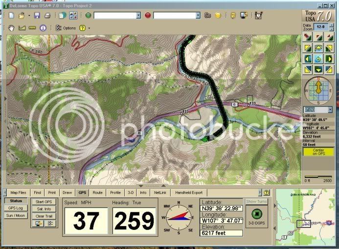
I also use a Delorme Earthmate with my laptop, and use TopoUSA as the mapping program. Works great:
On Amtrak (westbound CZ at Dotsero, CO):
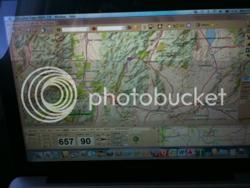
And in the air (eastbound US 300 near Butte, MT - 36,000 feet @ 657mph ground speed):
On Amtrak (westbound CZ at Dotsero, CO):
And in the air (eastbound US 300 near Butte, MT - 36,000 feet @ 657mph ground speed):
PetalumaLoco
Conductor
Do you ever get any flak using the GPS on an airliner?I also use a Delorme Earthmate with my laptop, and use TopoUSA as the mapping program. Works great:
On Amtrak (westbound CZ at Dotsero, CO):
And in the air (eastbound US 300 near Butte, MT - 36,000 feet @ 657mph ground speed):
Ryan
Court Jester
Looks like you have some Hackintosh action there, sweet! How do you get Delorme running?
- Joined
- Feb 18, 2003
- Messages
- 8,508
Windows 7 in VMware Fusion, Unity view. Win 7 runs like a dream on the MacBook Pro.Looks like you have some Hackintosh action there, sweet! How do you get Delorme running?
Last edited by a moderator:
- Joined
- Feb 18, 2003
- Messages
- 8,508
I have not, although I have heard of it happening. I'm reasonably discrete with it's use.Do you ever get any flak using the GPS on an airliner?
The following link shows the airlines that are OK with GPS, and those that are not. US is one that is not OK with GPS, but I have never been told to turn it off on US.
Airline GPS
PetalumaLoco
Conductor
I'm usually discrete, the one time I was not the Wicked Witch of the West stewardess made me put it away. I think it was US, too.I have not, although I have heard of it happening. I'm reasonably discrete with it's use.Do you ever get any flak using the GPS on an airliner?
The following link shows the airlines that are OK with GPS, and those that are not. US is one that is not OK with GPS, but I have never been told to turn it off on US.
Airline GPS
Ryan
Court Jester
Sweet, thanks - I've got VMware on one of my boxes but haven't played with unity view. I'm still amazed that nobody writes a decent GPS/mapping app for OS X.Windows 7 in VMware Fusion, Unity view. Win 7 runs like a dream on the MacBook Pro.Looks like you have some Hackintosh action there, sweet! How do you get Delorme running?
- Joined
- Jul 16, 2010
- Messages
- 4,887
A number of years ago, I used my Garmin IQue on a trip to Florida. I the Lounge Car with me was the conductor doing his ticket processing. I commented to him that the train was doing 81MPH. He told me to keep it quiet as the top speed allowed was 79.
Brandon V
Service Attendant
I bought Microsoft Streets and Maps for $24.95 online and then from Amazon a USB GPS antenna for about $25.00... very classy.. even shows where amtrak stations are and (most) rail lines. I'm going to be testing this in 15 days  It works quite nice on my laptop because i've already set it up and sat outside to let it get a signal. even picked up when i had the antenna inside and near the window.
It works quite nice on my laptop because i've already set it up and sat outside to let it get a signal. even picked up when i had the antenna inside and near the window.Can any one recomemend a GPS that comes pre loaded with all the info A train traveler would need, that I can get for around $150. Or less. I(think I??)only want to know where I am and how fast I am going. I would like it to have maps to show locations with nearby cities referenced.
amtrakwolverine
Engineer
I just got a Garmin Nuvi 265T for christmas. Will this work on the train?
Yes and you should purchase a USB to 110v adapter so you can plug it in on the trainI just got a Garmin Nuvi 265T for christmas. Will this work on the train?
the_traveler
Engineer
I once measured Amtrak's version of HSR doing 428 MPH!And in the air (eastbound US 300 near Butte, MT - 36,000 feet @ 657mph ground speed):
The only problem about it was
The Regional was still sitting at the platform at WAS, and had not even begun to move yet!

amtrakwolverine
Engineer
yeah it came with the USB for the laptop but that thing is not even a foot long. The adapter is only $16 from amazon.Yes and you should purchase a USB to 110v adapter so you can plug it in on the trainI just got a Garmin Nuvi 265T for christmas. Will this work on the train?
Latest posts
-

-
 B-29 Superfortress WWII bomber set to land in the Lehigh Valley
- Latest: AmtrakMaineiac
-

-

-

-