Subways of North America (XKCD)

Amtrak Unlimited Discussion Forum

Help Support Amtrak Unlimited Discussion Forum:

This site may earn a commission from merchant affiliate links, including eBay, Amazon, and others.

The Journalist

Lead Service Attendant
Joined
Dec 14, 2010
Messages
288
Location
Reno, Nevada
The webcomic xkcd has put together a "Subways of North America" map that is largely accurate...but pretends that they all link together in some fashion.

subways.png


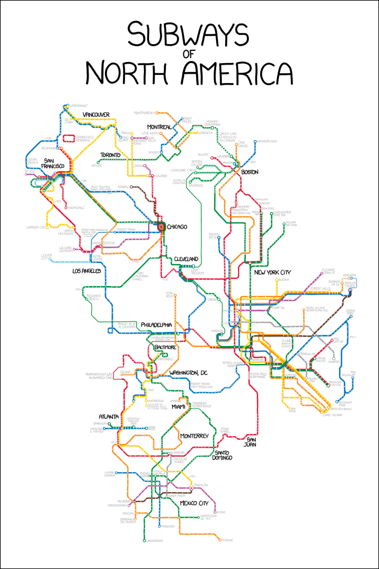
Of particular note is the "Forest Park-Pasedena Shuttle" that runs between Forest Park, IL and Pasedena, CA....every 15 minutes.
 
Oh god. I love that SO MUCH. I want to make it into a poster. I hope they sell it someday.

I love "xkcd". I've been following them for years. :)
 
Biggest "mistake" I can see is in Los Angeles, where the Gold Line is shown as orange, and the Orange Line is shown as yellow -- of course, that seems to be done so they can more easily be connected to San Francisco and Chicago.

The map ignores cities that have only light rail -- otherwise, it would be a lot more elaborate -- but does show light-rail lines in the cities that are depicted. (As well as some oddities, such as the Staten Island Ferry, and the aforementioned Los Angeles Orange Line, which is bus rapid transit.)
 
Biggest "mistake" I can see is in Los Angeles, where the Gold Line is shown as orange, and the Orange Line is shown as yellow -- of course, that seems to be done so they can more easily be connected to San Francisco and Chicago.
The map ignores cities that have only light rail -- otherwise, it would be a lot more elaborate -- but does show light-rail lines in the cities that are depicted.
Correct. Except that the map leaves out the Baltimore light rail.
 
The "large size" link on the page has this at the bottom:

For the pedantic rail enthusiasts, the definition of a subway used here is, with some caveats, "a network containing high capacity grade-separated passenger rail transit lines which run frequently, serve an urban core, and are underground or elevated for at least part of their downtown route." For the rest of you, the definition is "an underground train in a city."

Which explains why LA's Gold Line (shown in orange), Muni Metro, and SEPTA trolleys are on there, but Baltimore's light rail isn't. The LA Orange Line (shown in yellow) apparently is one the caveats...which begs the question of why Boston's Silver Line BRT isn't on there, since it DOES run underground.
 
I was on on trains the New York part of that map last weekend, and on the Boston one a few weeks before that. As nearly as I can tell, the map is quite accurate... although I did not try the Red line from New York to Boston... whatever it's named (I can't read it).

:mellow:
 
I was on on trains the New York part of that map last weekend, and on the Boston one a few weeks before that. As nearly as I can tell, the map is quite accurate... although I did not try the Red line from New York to Boston... whatever it's named (I can't read it).
Ashmont-Manhattan High-Speed Line, a pun on the real-life Ashmont-Mattapan High-Speed Line, a trolley that runs south from the end of the MBTA Red Line.
 
Back
Top